Europe is set for another heatwave after a short period of respite from the punishing temperatures this week.
Forecasters have said a “heat dome” continues to expand over the southern half of the continent.
What is a heat dome and why is it causing the current extremities in weather?
What is a heat dome?
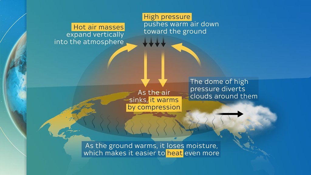
It’s when an area of high pressure stays over a large part of a region for days, or even weeks.
Like a lid on a saucepan, it traps hot air underneath, and can cause heatwaves with temperatures well above the norm.
How does a heat dome form?
Hot air expands vertically into the atmosphere then high pressure from above means it has nowhere to escape and pushes that warm air down.
As the warm air sinks, it compresses and heats up, which then traps more heat underneath.
The ground then heats up and loses moisture which makes it heat up even more, and means it is ripe for fires to start.
The dome of high pressure also pushes the clouds around it, keeping the heat in even more.
Usually, winds can move the high pressure around but as the dome stretches high into the atmosphere, the high-pressure system becomes very slow moving, almost stationary.

Are heat domes rare occurrences?
They are quite common in temperate zones but they are getting more intense and regular in areas that do not usually see such extreme heat.
Scientists from the US National Oceanic and Atmospheric Administration (NOAA) found the main trigger is a strong change in ocean temperatures during the preceding winter.
Leave a Reply